Geospatial Community March Newsletter
Next workshop – Thursday March 23rd, 2-4pm
We will have a combined session for our March workshop. In the first half, Christina will run through some R spatial basics.
Check out the material here. And if you want to follow along on your own computer during the workshop, download the code and data here. In the second half, we will host a problem-solving session. So bring along your spatial questions (ideally send them through before the workshop).
Previous workshop
Christina showed us how to measure area in R - PROPERLY. And it’s not as simple as you might think. Very much recommend watching the recording and reading the material if you ever need to measure area using R. (Please get in touch if you need the link.)
Geospatial Jobs
There are quite a few geospatial jobs going at the moment:
- Environmental GIS analyst, Eco-logical, Brisbane
- Senior Spatial Scientist and Spatial Scientist, NT government, Darwin
- Spatial Systems and Data Officer, Central Land Council, Alice Springs
- Natural capital data science internship (paid), Bush Heritage, remote
- Data integration and stratification intern (paid), Bush Heritage, remote
New Website!
We have been transferring all of the content from the old website made with blogdown, onto the new site made with QUARTO. Please check out the new site, and let Nick (n.wiggins at library dot uq dot edu dot au), who has been leading the switch, know if you find any issues. We also expect to move to a new domain shortly that reflects our new name.
Which brings me to….
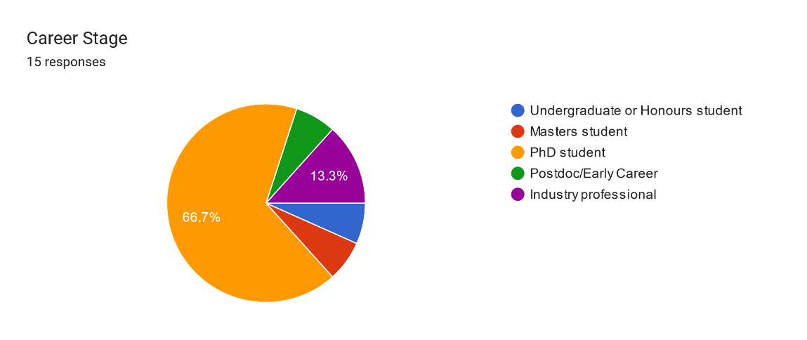
Survey results
Thanks to everyone who took to time to fill out our survey. Here are a few of the main results.
Who are we?
What should we be called?
We put it to the group to vote on a new name, mainly because a lot of our members are not affiliated with UQ – so UQ geospatial didn’t seem appropriate anymore. The most popular result was Geospatial Community, so we will stick with that.
Mission statement
From the survey results and some discussion among the organising committee, we also drafted a mission statement:
“Our mission is to build a supportive and inclusive community where students and professionals can grow their geospatial skills together.”
I hope this captures what the group is all about; please get in touch to suggested changes.
What people want to learn about?
There were some really interesting and topical suggestions for future workshops:
- How to handle big spatial data on the HPC – learn the basics of transferring data and scripts to the HPC, writing a bash shell script to submit a batch job to the HPC, and parallel processing to speed things up
- Pros and Cons of different GIS software, e.g., ArcGIS, QGIS, R, python, etc
- What is GDAL and why is it important for spatial data scientists to know about?
- How to model spatial data and deal with spatial autocorrelation
- Remote-sensing image analysis using machine learning We will do our best to find presenters to deliver workshops around these themes.
Organising committe
Huge thanks to
- Christina Buelow
- Catherine Kim
- Nick Wiggins
- Mitchel Rudge
- Tanya Dodgen
- Annie Nguyen
- Jason Dail
- Kaiching Cheong
for volunteering to help out on the organising committee. Excited for the year ahead 😊